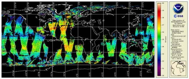
CoastWatch/OceanWatch produces 0.25-degree longitude/latitude Level-3 gridded sea-surface salinity (SSS) daily and 3-day mean datasets by box averaging European Space Agency (ESA) Soil Moisture – Ocean Salinity (SMOS) mission’s Microwave Imaging Radiometer with Aperture Synthesis (MIRAS) satellite observations over the global ocean.
Data Access
Product Overview
CoastWatch/OceanWatch produces 0.25-degree longitude/latitude Level-3 gridded sea-surface salinity (SSS) daily and 3-day mean datasets by box averaging European Space Agency (ESA) Soil Moisture – Ocean Salinity (SMOS) mission’s Microwave Imaging Radiometer with Aperture Synthesis (MIRAS) satellite observations over the global ocean.
CoastWatch/OceanWatch Level-3 SSS products are generated directly from the ESA MIRAS SMOS Level-2 swath NetCDF files (currently V6.62; see release "https://earth.esa.int/documents/10174/1854503/SMOS-Level-2-Ocean-Salinity-v662-release-note"). There are two SSS variables in V6.62 L2 NetCDF files, SSS_corr (corrected for land-sea contamination) and SSS_uncorr. The CoastWatch L3 product ingests the SSS_corr with values between 27 - 40 PSS. These products improve the application of satellite SSS products in NOAA by minimizing the data latency to within 24 hours of Level-2 data availability.
Product Details
| Short Names |
CoastWatch/OceanWatch binned-SMOS-L3
|
|---|---|
| Temporal Start Date |
May 1, 2010
|
| Product Families |
Sea Surface Salinity
|
| Measurements |
Sea Surface Salinity
|
| Processing Levels |
Level 3
|
| Latency Groups |
0 Hours <= 24 Hours (NRT)
|
| Latency Details |
24 hours |
| Spatial Resolution Groups |
2km+
|
| Spatial Resolution Details |
0.25° |
| Data Providers |
NOAA
NESDIS
STAR
CoastWatch
|
Spatial Coverage
Global
| Description |
180W - 180E |
|---|
Platforms
Documentation
- V6.62 Release Notes from ESA (link is external)contains links to other SMOS SSS product documents (such as ATDB, product specs, etc.)♦
- Barcelona Expert Center (2016). SMOS-BEC Ocean and Land Products Description. BEC-SMOS-0001-PD,Version 1.5. Technical report, BEC.
- Reagan, J., T. Boyer, J. Antonov, and M. Zweng (2014), Comparison analysis between Aquarius sea surface salinity and World Ocean Database in situ analyzed sea surface salinity, J. Geophys. Res. Oceans, 119, 8122–8140, doi:10.1002/2014JC009961(link is external)♦.
- SMOS-BEC Team 2016: SMOS-BEC Ocean and Land Products Description. BEC-SMOS-0001-PD.pdf , version 1.5
- SMOS Team, 2014: SMOS L2 OS Input/output data definition. SO-TN-ARG-GS-009. Issue 2, Rev 25, 5 September, 2014. ARGANS