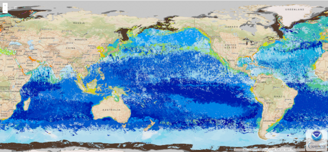
MBON Seascapes identifies spatially explicit water masses with particular biogeochemical features using a model and satellite-derived measurements. The seascape product is generated as monthly and 8-day composites at 5 km spatial resolution
Data Access
Product Overview
The US and global Marine Biodiversity Observation Network (MBON) partnered with the US Integrated Ocean Observation System (IOOS), NOAA/OAR/AOML and NOAA/NESDIS/STAR to develop and routinely generate this Seascape Pelagic Habitat Classification product (MBON Seascapes) and make it available on CoastWatch. Derived from dynamic fields of satellite and modelled data, MBON Seascapes are classified and used as a biogeographical framework to describe dynamic, changing ocean habitats for MBON and other applications. MBON Seascapes provide information about the quality and extent of different oceanographic habitats or features and can be used to assess and predict the different planktonic and fisheries communities that reside within seascapes. Current MBON Seascapes products include monthly and 8-day time steps at 5 km resolution. High resolution (1 km) case studies are planned on a case by case basis through cooperation with US and global MBON partners.
MBON Seascapes identifies spatially explicit water masses with particular biogeochemical features using a model and satellite-derived measurements. The seascape product is generated as monthly and 8-day composites at 5 km spatial resolution.
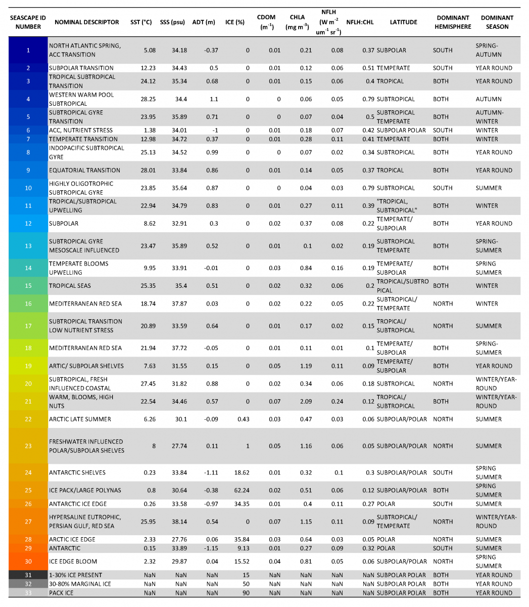
Table of Seascape ID number definitions. SST, sea surface temperature; SSS sea surface salinity; ADT, absolute dynamic topography; ICE, Ice; CDOM, chromophoric dissolved organic material; CHLA, chlorophyll-a; NFLH, normalized fluorescent line height; NaN, not a number.
Product Details
| Short Names |
seascapes
|
|---|---|
| Temporal Coverage |
Monthly and 8-Day |
| Product Families |
Seascape Classification
|
| Measurements |
Pelagic Seascape Classification
|
| Processing Levels |
Level 4
|
| Latency Groups |
24+ hours (Delayed)
|
| Spatial Resolution Groups |
2km+
|
| Spatial Resolution Details |
5 km |
| Data Providers |
NOAA
NESDIS
STAR
CoastWatch
|
Spatial Coverage
Global
| Description |
180W - 180E |
|---|
Platforms
Instruments
Documentation
- Montes Enrique, Djurhuus Anni, Muller-Karger Frank E., Otis Daniel, Kelble Christopher R., Kavanaugh Maria T., 2020. Dynamic Satellite Seascapes as a Biogeographic Framework for Understanding Phytoplankton Assemblages in the Florida Keys National Marine Sanctuary, United States. Frontiers in Marine Science, 7, https://doi.org/10.3389/fmars.2020.00575
- Kavanaugh, M.T., Church, M.J., Davis, C.O., Karl, D.M., Letelier, R.M. and Doney, S.C., 2018. ALOHA from the Edge: Reconciling three decades of in situ Eulerian observations and geographic variability in the North Pacific Subtropical Gyre. Frontiers in Marine Science, 5, p.130.
- Muller-Karger, F., Digna Rueda-Roa, Francisco Chavez, Maria Kavanaugh, and Mitchell A. Roffer. 2017. Megaregions Among the Large Marine Ecosystems of the Americas. Environmental Development. http://dx.doi.org/10.1016/j.envdev.2017.01.005.
- Kavanaugh, M.T., Oliver, M J., Chavez, F. P., Letelier, R.M., Muller-Karger, F.E., Doney, S.C. 2016. Seascapes as a new vernacular for ocean monitoring, management and conservation. ICES Journal of Marine Science. doi:10.1093/icesjms/fsw086.
- Kavanaugh, M.T., Hales, B., Saraceno, M., Spitz, Y.H., White, A.E. and Letelier, R.M., 2014. Hierarchical and dynamic seascapes: A quantitative framework for scaling pelagic biogeochemistry and ecology. Progress in Oceanography, 120, pp.291-304.
- Muller-Karger, F.E., M.T. Kavanaugh, E. Montes, W.M. Balch, M. Breitbart, F.P. Chavez, S.C. Doney, E.M. Johns, R.M. Letelier, M.W. Lomas, H.M. Sosik, and A.E. White. 2014. A framework for a marine biodiversity observing network within changing continental shelf seascapes. Oceanography 27(2):18–23, http://dx.doi.org/10.5670/oceanog.2014.56.